Tropical Storm and Hurricane Olga Page
Current Tropical Weather Discussion
  Added as the Storm Progresses      Public Advisory  Forecast/Advisory     Discussion   Maps/Charts   Wind Probs

NHC Advisory Mailing Lists    North Atlantic - Water Vapor Loop   North Atlantic - Infrared Channel 2 Loop
         Index          


Add This Page To Favorites
      Tropical Storm Olga Movie File 8 MB
OCHA Situation Report No. 1 Dominican Republic: Tropical Storm Olga 13 December 2007
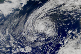
December 12, 2007 -- 

Olga Degenerating Into A Broad Area Of Low Pressure With A Few Squalls...  

At 1000 PM EST the center of Tropical Depression Olga was located near latitude 18.9 north - longitude 77.6 west or about 80 miles northwest of Kingston Jamaica and about 235 miles east of Grand Cayman.  The depression has slowed down and is now moving toward the west near 13 mph. This general motion is expected to continue during the next 24 to 36 hours.  Maximum sustained winds are near 30 mph, with higher gusts confined to a few squalls north of the center.  The depression is expected to become a remnant low within the next 12 hours or so.  Estimated minimum central pressure is (1008 mb) 29.77 inches.  Olga is expected to produce additional rainfall accumulations of 1 to 2 inches over the southeastern Bahamas, eastern Cuba, Jamaica and Hispaniola. These rains could produce life-threatening flash floods and mud slides.   This is the last public advisory issued by the national hurricane center on this system unless regeneration occurs. Additional information on this system can be found in high seas forecasts issued by the National Weather Service, under awips header  nfdhsfat1 and wmo header fznt01 kwbc.  


Infra Red 
-- MPG Movie

Visible
-- MPG Movie

Water Vapor
-- MPG Movie
 2007 -- Hurricane -- Tropical Storm Olga Diary

(return to top of page)
Current Weather Watches                                 The lastest 8 MB Mov File From NASA

Current Weather Watches map                           Links to the lastest 8 MB Mov File From NASA

Today's National
Forecast                            Current  Weather              National Weather Warnings
NOAA Current Watches/Warnings        Current Weather map          National Weather Warnings Map
Day 1 Forecast  Precipitation                                Day 2 Forecast Precipitation

        Day 1 Forecast Precipitation map                 Day 2 Forecast Precipitation map
  (return to top of page)
The Rothstein Catalogue!

States
Alabama Emergency Management Agency
Arkansas Department of Emergency Management
Delaware Emergency Management Agency
Florida Division of Emergency Management
Georgia Office of Homeland Security - GEMA
Louisiana Office of Homeland Security and Emergency Preparedness
Maryland Emergency Management Agency
Massachusetts Emergency Management Agency
Mississippi Emergency Management Agency
North Carolina Division of Emergency Management
The Oklahoma Department of Emergency Management
South Carolina Emergency Preparedness Division
Tennessee Emergency Management Agency
Texas Emergency Management Agency
Virginia Department of Emergency Management

Traffic
Alabama: Traffic Information Line: 1-800-843-0699
Florida: Emergency Information Line: 1-800-342-3557
Louisiana: Traffic Information Line: 1-800-256-7036
Massachusetts Traffic Information
Mississippi: Traffic Information Line: 1-800-222-6362
Texas: Highway Conditions Information: 1-800-452-9292
(return to top of page)

Local Governments and Sheriff's Offices
Added as the Storm Progresses

Local Emergency Management Offices
Added as the Storm Progresses

(return to top of page)

Evacuation
Disaster & Emergency Insurance Claim Reporting Information
FEMA tele-registration – 1-800-621-FEMA (3362)  (For Individuals)  Call TTY 1-800-462-7585 for people with speech or hearing disabilities -- www.fema.gov
Red Cross call center  - 800 HelpNow or 800 Get-Info (nationwide)
Salvation Army – 800 SAL-ARMY (800.725.2769)
Find Loved Ones
 American Red Cross         877.568.3317  www.familylinks.icrc.org or www.redcross.org
Find Family National Call Center           866.326.9393
Lost Children:      Children’s Assessment Center  713.986.3300
Salvation Army's Team Emergency Radio Network (SATERN) Activated Send an online request to locate missing family and friends. If you can't connect to the site immediately, please try again.
Search and Rescue, U.S. Coast Guard Requests for rescues of missing or stranded persons will be entered into the system, viewed by command center and prioritized as received.
Red Cross Alert for Persons with Emergency Medical ConditionsThe Red Cross is only accepting phone calls to search for missing persons in these emergency circumstances: insulin dependant diabetics, oxygen dependant, dialysis patient, blind, recent heart attack or stroke victims, mobility challenged, broken leg, foot or ankle, or paralyzed.
(return to top of page)

Federal
National Hurricane Center
NOAA Central Pacific Hurricane Center
Naval Pacific Meteorology and Oceanography Center Joint Typhoon Warning Center
NOAA National Weather Service
FEMA
Dr. Gray's Seasonal Hurricane Forecast 
FEMA - Press
FEMA For Kids: Hurricanes
FEMA Emergency Managers Reports
FEMA - Photo Library
National Park Service  - Morning Report
The U.S. Army Corps of Engineers
Hurricane Katrina Response; Environmental Protection Agency
  (return to top of page)
HHS - Disasters and Emergencies: Hurricanes
SAMHSA's Disaster Mental Health Resource Kit  1-800-789-2647 for bilingual information services (1-866-889-2647: TDD) Monday through Friday, 8:30 a.m. to 5 p.m. EST.
National Incident Management Situation Report by NICC -- PFD
US Army Corps of Engineers - New Orleans District Task Force
US Coast Guard - Storm Watch
Office of Electricity Delivery and Energy Reliability: Infrastructure Security and Energy Restoration
Advisory Situation Reports from The HSUS Disaster Center
Disaster Contractors Network Situation Reports
(return to top of page)

International
International Strategy for Disaster Reduction 
Reliefweb International
The Caribbean Disaster Emergency Response Agency
Caribbean Hurricane Network 
Canadian Hurricane Centre
Canadian Hurricane Track Information 
(return to top of page)

Preparedness
Why Talk About Hurricanes?
The "Standard" Family Disaster Plan
Broward Florida's -- Hurricane Prep. Fact Sheets
Florida's DEM -- Hurricane Retrofit Guide
FEMA: Are you Ready -- Hurricane Preparedness
Weathering the storm : How safe is your home?
American Red Cross — Hurricane Readiness Guide
NOAA Hurricanes Natures GreaOlga Storms
THE Hurricanes FAQ

Hurricanes: The Basics
Home Security
US Fire Administration -- Hurricane and Tornado Fire Safety Factsheet HSUS and FEMA --
FEMA Agaist the Wind: Protecting Your Home from Hurricane and Wind Damage -- PDF
FEMA After a Flood: The First Steps
Standard Family Disaster Plan. 
Community Hurricane Preparedness.
Education Hurricanes - CotF
(return to top of page)

Animals
HSUS Disaster Center
Animals and Emergencies
Pet Supplies
(return to top of page)

Tracking
NHC/TPC RSS Feeds
National Data Buoy Center
Hurricane Tracking Chart 
Color Hurricane Tracking Chart 
NOAA Storm Tracker 
NOAA Weather Radio
Home Weather Station
Map Hurricane Risk in United States 
The Hurricane FAQ
TPC NHC -- Saffir -- Simpson Hurricane Scale
Atlantic Hurricane Archive -- Storm Archive: Java™ Animated Plots and ASCII Data files, 1886 - 2005
Hurricane Hunters - 53 WRS
(return to top of page)

Mitigation
Hurricane Damage to Residential Structures: Risk and Mitigation
Designing for wind speed map 
The Saffir-Simpson Scale 
Insurance Q and A 
Education Hurricanes - CotF
My Safe Florida Home
Wind Speed Construction Design Map
The Disaster Center Contact the Disaster Center The Rothstein Cataloge on Disaster Recovery What Code Do You Need?
 Administration Plan Review Residential Code Fire Code Building Code Plumbing Code Mechanical Code
Electrical Code Fuel Gas Code Private Sewage Code Energy Conservation Code
Existing Building Code
Performance Code Wildland-Urban Code Property Maintenance Code State and International Codes
Masonry and Steel Codes Alternative Construction Storm Shelters Building for Disasters Green Home
Legacy Codes: Southern Building Congress International Conference of Building Officials Building Officials and Code Administrators International
(return to top of page)
If you have any Questions, Comments or suggestions please send an email to:
Host@disastercenter.com
Google
 
Flooding
Massachusetts Real-Time Water Data
Arkansas Real-Time Water Data
Florida Real-Time Water Data 
Louisiana Real-Time Water Data
Texas Real-Time Water Data
Make an Online Hazard Map for Your Location
National Data Buoy Center
NOAA Tides and Currents 
NWS River Forecast Information
NWS Flash Flood Guidance
NWS Significant River Flood Outlook
USGS Current Water Resources Conditions
nowCOAST: GIS Mapping Portal to Real-Time Environmental Observations and NOAA Forecasts
National Flood Insurance Program
National Weather Service Precipitation Analysis
(return to top of page)

Satellites and Radar
NOAA GOES Satellite Imagery for Tropical Sectors
NOAA Multi-Dimensional Imagery from Polar Orbiting and Geostationary Satellites
Naval Research Laboratory (NRL) Monterey Marine Meteorology Division Tropical Cyclone Information
NASA MODIS Rapid Response System
MODIS image of the day
NWS National Doppler Radar Sites  
NASA - LaOlga Hurricane News
NASA - Multimedia Features
NASA - Hurricane Resource Reel
Atlantic Sea Surface Temperature Analisis 
Atlantic Sea Surface Temperature Anomaly 

(return to top of page)

Track Analysis/Best Track
National Hurricane Center/Tropical Predictions Center Archive of Past Hurricane Seasons
Historical Hurricane Tracks
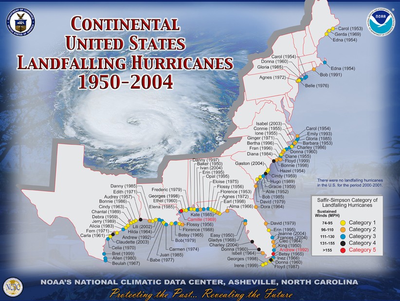
Continental US Landfall of Hurricanes 1950 - 2004
Atlantic Hurricane Archive
(return to top of page)

Shoreline Change
United States Geological Survey (USGS) Coastal and Marine Geology Program Internet Map Server
USGS Hurricane and Extreme Storm Impact Studies
USGS Mapping Coastal Change Hazards
NOAA Coastal Services Center Topographic Data
(return to top of page)

Environmental Affects
NOAA Office of Response and Restoration
(return to top of page)

Health Affects
Morbidity and Mortality Weekly Reports
For the CDC index on hurricane information (including fact sheets in English and other languages), please see: 
CDC"s Hurricane Index
For CDC information specific to healthcare professionals
Hurricane-Related Documents and Resources Recently Released or Updated
Drive Safely
http://www.bt.cdc.gov/disasters/pdf/flyer-drive-safely.pdf
Returning Home After a Hurricane: Be Healthy and Safe
http://www.bt.cdc.gov/disasters/hurricanes/returnhome.asp
Cleaning and Sanitizing With Bleach after an Emergency
http://www.bt.cdc.gov/disasters/bleach.asp
Varicella Info from NIP
http://www.cdc.gov/nip/diseases/varicella/
Addition of Safe Water Tips to Announcer Read PSAs
http://www.bt.cdc.gov/disasters/hurricanes/psa_announcerreads.asp#rita
Disposal of Contaminated Medical Devices – FDA site
http://www.fda.gov/cdrh/emergency/disposal.html
Natural Disaster Response – FDA site
http://www.fda.gov/cder/emergency/  
Carbon Monoxide Poisoning After Hurricane Katrina --- Alabama, Louisiana, and Mississippi, August--September 2005 – MMWR Article
http://www.cdc.gov/mmwr/preview/mmwrhtml/mm54e930a1.htm
 
The following documents have been recently UPDATED:
Effects of Hurricane Katrina on Children's Blood Lead Levels
http://www.bt.cdc.gov/disasters/hurricanes/katrina/leadkatrina.asp

Translations for the following documents are now available:
(return to top of page)


Damage Assessment and Post-Storm Impact Data
Recovering From and Coping With Flood Damaged Property after Returning Home
The Disaster Assistance Process for Individuals
(return to top of page)

Other sites

The Hurricane Watch Net
HurricaneTrack.com
Caribbean Hurricane Network
Hurricane Strike! Hurricane Science & Safety For Students
DURING A HURRICANE WATCH
(A Hurricane Watch is issued when there is a threat of hurricane conditions within 24-36 hours.)
1. Listen to a battery-operated radio or television for hurricane progress reports.
2. Check emergency supply kit.
3. Fuel car.
4. Bring in outdoor objects such as lawn furniture, toys, and garden tools and anchor objects that cannot be brought inside.
5. Secure buildings by closing and boarding up windows. Remove outside antennas.
6. Turn refrigerator and freezer to coldest settings. Open only when absolutely necessary and close quickly.
7. Store drinking water in clean bathtubs, jugs, bottles, and cooking utensils.
8. Store valuables and personal papers in a waterproof container on the highest level of your home. 9. Review evacuation plan.
10. Moor boat securely or move it to a designated safe place. Use rope or chain to secure boat to trailer. Use tiedowns to anchor trailer to the ground or house.
Source: floridadisaster.org/      Florida's Division of Emergency Management
(return to top of page)

 
History of Storms Named  Olga --  In 2001 Olga became Hurricane Olga which stayed out to sea Tracking information  2001 Tropical Cyclone Report - Hurricane Olga  Ogal replaced the name Opal, which made landfall in Florida as a class 3 hurricane in 1995.  At the time Opal was the most destructive hurricane to hit the U.S. mainland since Hurricane Andrew. Preliminary estimates of insured property damage for the U.S. were $2.1 billion, with total damage estimates possibly reaching $3 billion. The estimated direct U.S. death toll from Opal was 9.  IR satellite image from 12Z 04 OCT of Opal at peak intensity -- IR satellite image from 22Z 04 OCT of Opal making landfall -- IR satellite movie of Opal -- Tropical cyclone report for Hurricane Opal-- Opal 1995- Tracking information  


Year 2007 Hurricane Olga Diary
December 12, 2007 -- 

Olga weakens to a depression...  

At 4 PM EST the government of the Bahamas has discontinued all tropical storm warnings.  For storm information specific to your area, including possible inland watches and warnings, please monitor products issued by your local weather office.  

At 400 PM EST the center of Tropical Depression Olga was located near latitude 18.9 north - longitude 76.9 west or about 65 miles north of Kingston Jamaica and about 280 miles of Grand Cayman.  The depression is moving toward the west near 23 mph...and this general motion is expected to continue for the next 24 hours.  Maximum sustained winds are near 35 mph, with higher gusts.  Olga could degenerate into a remnant low tonight.  Estimated minimum central pressure is (1007 mb) 29.74 inches.  Olga is expected to produce additional rainfall accumulations of 1 to 2 inches over the southeastern Bahamas. Rainfall amounts of 2 to 4 inches are possible over eastern Cuba, with isolated maximum accumulations of 8 inches. Additional rainfall amounts of 1 to 2 inches are possible over Hispaniola, with isolated storm total amounts of 10 inches. These rains are expected to produce life-threatening flash floods and mud slides in Hispaniola.  
December 12, 2007 -- Olga continues westward

A tropical storm warning remains in effect for the southeastern Bahamas and the Turks and Caicos Islands.  For storm information specific to your area, including possible inland watches and warnings, please monitor products issued by your local weather office.  

At 100 PM EST the center of Tropical Storm Olga was located near latitude 19.0 north - longitude 76.0 west or about 85 miles southwest of Guantanamo Cuba.  Olga is moving toward the west near 23 mph and this motion is expected to continue for the next 24 hours.  Maximum sustained winds are near 40 mph, with higher gusts.  These winds are mainly confined to a few bands well to the northeast of the center.  Olga could dissipate as a tropical cyclone later today.  Tropical storm force winds extend outward up to 345 miles to the northeast of the center.  Estimated minimum central pressure is (1009 mb) 29.80 inches.  Olga is expected to produce additional rainfall accumulations of 1 to 2 inches over the southeastern Bahamas.  Rainfall amounts of 2 to 4 inches are possible over eastern Cuba, with isolated maximum accumulations of 8 inches.  Rainfall amounts of 4 to 6 inches are possible over Hispaniola, with isolated maximum amounts of 10 inches.  These rains are expected to produce life-threatening flash floods and mud slides in Hispaniola.

December 12, 2007 --  Olga Weakening As The Center Reaches The Windward Passage...   

A tropical storm warning remains in effect along the northern coast of Hispaniola from Cabo Engano in the Dominican Republic to Le Mole St. Nicholas Haiti.  A tropical storm watch remains in effect for the southern coast of the Dominican Republic from Cabo Engano to Punta Palenque.  These warnings and watches will likely be discontinued later today.   A tropical storm warning remains in effect for the southeastern Bahamas and the Turks and Caicos Islands.   Tropical storm conditions are possible over portions of eastern Cuba today.   Interests in Jamaica and the Cayman Islands should monitor the progress of Olga.   For storm information specific to your area, including possible inland watches and warnings, please monitor products issued by your local weather office.   

At 800 AM AST the center of Tropical Storm Olga was located near latitude 19.3 north - longitude 73.8 west or about 65 miles south-southeast of the eastern tip of Cuba, and about 110 miles west-northwest of Port Au Prince Haiti.   Olga is moving toward the west near 19 mph, and this motion is expected to continue for the next 24 hours.  This motion should bring the center of Olga near the southern coast of eastern Cuba today.   Maximum sustained winds have decreased to near 45 mph, with higher gusts.  Satellite imagery indicates that Olga has become disorganized, and further weakening is forecast during the next 24 hours.  Olga could weaken to a tropical depression later today.   Tropical storm force winds extend outward up to 260 miles over water to the north and east of the center.  Turks island recently reported sustained winds of 38 mph.   Estimated minimum central pressure is (1007 mb) 29.74 inches.   Olga is expected to produce additional rain accumulations of 1 to 2 inches over Puerto Rico and the southeastern Bahamas, with isolated maximum storm total amounts of 12 inches over Puerto Rico. Rainfall amounts of 4 to 6 inches are possible over Hispaniola with possible isolated maximum totals of 10 inches. These rains are expected to produce life-threatening flash floods and mudslides in Puerto Rico and Hispaniola.  Rainfall amounts of 2 to 4 inches are possible over eastern Cuba with possible isolated maximum totals of 10 inches.    

December 12, 2007 --  Center Of Olga Moving Into Haiti...Heavy Rain Threat Continues...  

A tropical storm warning remains in effect along the northern coast of Hispaniola from Cabo Engano in the Dominican Republic to Le Mole St. Nicholas Haiti.  A tropical storm watch remains in effect for the southern coast of the Dominican Republic from Cabo Engano to Punta Palenque.  These warnings and watches will likely be discontinued later today.   A tropical storm warning remains in effect for the southeastern bahamas and the turks and caicos islands.   Tropical storm conditions are possible over portions of eastern Cuba today.   Interests in Jamaica and the Cayman Islands should monitor the progress of Olga.   For storm information specific to your area, including possible inland watches and warnings, please monitor products issued by your local weather office.   

At 500 AM AST the center of Tropical Storm Olga was located near latitude 19.2 north - longitude 72.5 west or about 45 miles north-northwest of port au prince Haiti and about 130 miles east-southeast of the eastern tip of Cuba.   Olga is moving toward the west near 18 mph, and this motion is expected to continue for the next 24 hours.  This motion should bring the center of Olga over the Caribbean Sea between Haiti and Cuba this morning...and near the southern coast of eastern Cuba later today.   Maximum sustained winds are near 50 mph, with higher gusts.  Weakening is forecast during the next 24 hours, and Olga could weaken to a tropical depression later today or tonight.   Tropical storm force winds extend outward up to 260 miles over water to the north and east of the center.   Estimated minimum central pressure is (1006 mb) 29.71 inches.   Olga is expected to produce additional rain accumulations of 1 to 2 inches over Puerto Rico and the southeastern Bahamas, with isolated maximum storm total amounts of 12 inches over Puerto Rico. Rainfall amounts of 4 to 6 inches are possible over Hispaniola with possible isolated maximum totals of 10 inches. These rains are expected to produce life-threatening flash floods and mudslides in Puerto Rico and Hispaniola.  Rainfall amounts of 2 to 4 inches are possible over eastern Cuba with possible isolated maximum totals of 10 inches.  

December 12, 2007
-- Olga Losing Some Organization As It Crosses Hispaniola...Heavy Rains Continue... 

A tropical storm warning remains in effect along the northern coast of Hispaniola from Cabo Engano in the Dominican Republic to Le Mole St. Nicholas Haiti.  A tropical storm warning remains in effect for the southeastern Bahamas and the Turks and Caicos Islands.  A tropical storm watch remains in effect for the southern coast of the Dominican Republic from Cabo Engano to Punta Palenque.  For storm information specific to your area, including possible inland watches and warnings, please monitor products issued by your local weather office.  

At 200 AM AST the center of Tropical Storm Olga was located inland over Hispaniola near latitude 19.0 north...longitude 71.4 west or about 65 miles east-northeast of port-au-prince Haiti and about 195 miles east-southeast of the eastern tip of Cuba.  Olga is moving toward the west near 16 mph and this general motion is expected to continue during the next 24 hours. On this track...the center of a weaker Olga should move over the Windward Passage later today and then over the waters between Cuba and Jamaica.  Surface observations indicate that maximum sustained winds have decreased to near 50 mph, with higher gusts.  Olga is expected to weaken to a tropical depression during the next 24 hours.  Tropical storm force winds extend outward up to 240 miles to the north and east of the center.  Estimated minimum central pressure is (1005 mb) 29.68 inches.  Olga is expected to produce additional rain accumulations of 2 to 4 inches over Puerto Rico and the southeastern Bahamas, with isolated maximum storm total amounts of 12 inches over Puerto Rico. Rainfall amounts of 4 to 6 inches are possible over Hispaniola with possible isolated maximum totals of 10 inches. These rains are expected to produce life-threatening flash floods and mudslides in Puerto Rico and Hispaniola.  

December 11, 2007 -- Olga Traversing Hispaniola Producing Heavy Rains... 

A tropical storm warning remains in effect along the northern coast of Hispaniola from Cabo Engano in the Dominican Republic to Le Mole St. Nicholas Haiti.  A tropical storm warning remains in effect for the southeastern Bahamas and the Turks and Caicos Islands.  A tropical storm watch remains in effect for the southern coast of the Dominican Republic from Cabo Engano to Punta Palenque.  For storm information specific to your area...including possible inland watches and warnings...please monitor products issued by your local weather office.  

At 1100 PM AST the center of Tropical Storm Olga was located inland over Hispaniola near latitude 19.0 north - longitude 70.6 west or about 55 miles northwest of Santo Domingo in the Dominican Republic and about 250 miles east-southeast of the eastern tip of Cuba.  Olga is moving toward the west near 15 mph and this general motion is expected to continue during the next 24 hours. On this track, the center of a weaker Olga should move over the Windward Passage and then over the waters between Cuba and Jamaica late Wednesday.    Maximum sustained winds are near 60 mph, with higher gusts.  Olga is expected to weaken to a tropical depression during the next 24 hours.   Tropical storm force winds extend outward up to 240 miles to the north and east of the center.  Estimated minimum central pressure is (1004 mb) 29.65 inches.  Olga is expected to produce additional rain accumulations of 2 to 4 inches over Puerto Rico and the southeastern Bahamas, with isolated maximum storm total amounts of 12 inches over Puerto Rico. Rainfall amounts of 4 to 6 inches are possible over Hispaniola with possible isolated maximum totals of 10 inches. These rains are expected to produce life-threatening flash floods and mudslides in Puerto Rico and Hispaniola.  

December 11, 2007 -- Hurricane Hunter Plane Finds Olga A Little Stronger With Tropical Characteristics... 

A tropical storm warning remains in effect along the northern coast of Hispaniola from Cabo Engano in the Dominican Republic to Le Mole St. Nicholas Haiti.  A tropical storm warning remains in effect for the southeastern Bahamas and the Turks and Caicos Islands.  A tropical storm watch remains in effect for the southern coast of the Dominican Republic from Cabo Engano to Punta Palenque.  For storm information specific to your area...including possible inland watches and warnings...please monitor products issued by your local weather office.  Data from a hurricane hunter plane indicate that the stronger winds are now closer to the center suggesting that Olga has transitioned to a tropical storm.   

At 800 PM AST the center of Tropical Storm Olga was located inland over the Dominican Republic near latitude 18.8 north...longitude 69.5 west or about 30 miles, North- northeast of Santo Domingo in the Dominican Republic and just south of Bahia De Samana.  Olga is moving on a general westward track near 13 mph and this general motion is expected to continue for the next 24 hours.  The center of Olga is expected to remain over land for much of the next 24 hours.  Data from a reconnaissance plane indicate that the maximum sustained winds have increased to near 60 mph, with higher gusts.  These winds are confined to an area just north of the center. A slow weakening is forecast over the next 24 hours.  Tropical storm force winds extend outward up to 240 miles, mainly to the northeast and northwest of the center. Copey International Airport on the north coast of the Dominican Republic just measured wind gusts to 63 mph. Estimated minimum central pressure is (1003 mb) 29.62 inches.  Olga is expected to produce additional rain accumulations of 2 to 4 inches over Puerto Rico and the southeastern Bahamas...with isolated maximum storm total amounts of 12 inches over Puerto Rico. Rainfall amounts of 4 to 6 inches are possible over Hispaniola with possible isolated maximum totals of 10 inches. These rains are expected to produce life-threatening flash floods and mudslides in Puerto Rico and Hispaniola.  

December 11, 2007 -- Center Of Olga Inland Over The Dominican Republic... 

A tropical storm warning remains in effect along the northern coast of Hispaniola from Cabo Engano in the Dominican Republic to Le Mole St. Nicholas Haiti.  A tropical storm warning remains in effect for the southeastern Bahamas and the Turks and Caicos Islands.  A tropical storm watch remains in effect for the southern coast of the Dominican Republic from Cabo Engano to Punta Palenque.  For storm information specific to your area, including possible inland watches and warnings, please monitor products issued by your local weather office. 

At 500 PM AST the center of Subtropical Storm Olga was located inland over the Dominican Republic near latitude 18.5 north - longitude 68.8 west or about 70 miles east of Santo Domingo in the Dominican Republic.  Olga is moving toward the west near 13 mph, and this general motion is expected to continue for the next 24 hours.  The center of Olga is expected to remain over land for much of the next 24 hours.  Maximum sustained winds are near 45 mph, with higher gusts.  Slow weakening is forecast over the next 24 hours.  Winds of 40 mph extend outward up to 240 miles, mainly to the northeast and northwest of the center.  Estimated minimum central pressure is (1003 mb) 29.62 inches.  Olga is expected to produce additional rain accumulations of 2 to 4 inches over Puerto Rico and the southeastern Bahamas, with isolated maximum storm total amounts of 12 inches over Puerto Rico. Rainfall amounts of 4 to 6 inches are possible over Hispaniola with possible isolated maximum totals of 10 inches. These rains are expected to produce life-threatening flash floods and mudslides in Puerto Rico and Hispaniola.

December 11, 2007 -- Center Of Olga Making Landfall In The Dominican Republic...  

At 2 PM AST the government of the Bahamas has issued a tropical storm warning for the southeastern Bahamas and for the Turks and Caicos Islands.  A tropical storm warning remains in effect along the northern coast of Hispaniola from Cabo Engano in the Dominican Republic to Le Mole St. Nicholas Haiti.   A tropical storm watch remains in effect for the southern coast of the Dominican Republic from Cabo Engano to Punta Palenque.   For storm information specific to your area, including possible inland watches and warnings, please monitor products issued by your local weather office.  

At 200 PM AST the center of Subtropical Storm Olga was located near latitude 18.5 north - longitude 68.4 west or along the coast at the easternmost tip of the Dominican Republic near Punta Cana.  This position is also about 85 miles east of Santo Domingo.   Over the past several hours Olga has been moving to the west- northwest at 10 mph, but a return to a westward track is expected over the next 24 hours.  The center of Olga is expected to be near or over the island of Hispaniola for much of the next 24 hours.   Maximum sustained winds are near 45 mph, with higher gusts.  Slow weakening is expected over the next day or so.   Olga's strongest winds are located well away from the center of circulation...which is a characteristic of subtropical cyclones. Winds of 40 mph extend outward up to 275 miles  to the north and northeast of the center.    Estimated minimum central pressure is (1005 mb) 29.68 inches.   Olga is expected to produce additional rain accumulations of 2 to 4 inches over Puerto Rico and the Virgin Islands...with isolated maximum storm total amounts of 12 inches over Puerto Rico. Rainfall amounts of 4 to 6 inches are possible over Hispaniola with possible isolated maximum totals of 10 inches. These rains have already produced life-threatening flash floods and mudslides in Puerto Rico.  

December 11, 2007 -- Warning Extended Westward Along The North Coast Of Hispaniola... 

At 11 AM AST a tropical storm warning has been issued for the north coast of Haiti from the border with the Dominican Republic westward to Le Mole St. Nicholas at the northwestern tip of Haiti.  A tropical storm warning is now in effect along the northern coast of Hispaniola from Cabo Engano in the Dominican Republic to Le Mole St. Nicholas Haiti.   A tropical storm watch remains in effect for the southern coast of the Dominican Republic from Cabo Engano to Punta Palenque.   A tropical storm watch or warning may be required for the southeastern Bahamas and the Turks and Caicos Islands later today.   For storm information specific to your area...including possible inland watches and warnings...please monitor products issued by your local weather office.  

At 1100 AM AST the center of Subtropical Storm Olga was located near latitude 18.1 north - longitude 68.0 west or about 130 miles east-southeast of Santo Domingo in the Dominican Republic and about 125 miles west of San Juan Puerto Rico.   Olga is moving just south of due west near 15 mph, and this general motion is expected to continue for the next 24 hours.  On the forecast track...the center of Olga is expected to pass very close to the southern coast of the Dominican Republic later today.   Maximum sustained winds are near 45 mph, with higher gusts.  Little change in strength is expected today...but some weakening is likely tomorrow as Olga encounters strong upper-level winds.   Olga's strongest winds are located well away from the center of circulation, which is a characteristic of subtropical cyclones. Winds of 40 mph extend outward up to 275 miles to the north and northeast of the center. NOAA buoy 41043, about 270 miles from the center, recently reported a sustained wind of 40 mph with a gust to 54 mph.    Estimated minimum central pressure is (1005 mb) 29.68 inches.   Olga is expected to produce additional rain accumulations of 2 to 4 inches over Puerto Rico and the Virgin Islands...with isolated maximum storm total amounts of 12 inches over Puerto Rico. Rainfall amounts of 4 to 6 inches are possible over Hispaniola with possible isolated maximum totals of 10 inches. These rains have already produced life-threatening flash floods and mudslides in Puerto Rico.    


December 11, 2007 Center Of Olga Now Just West Of Puerto Rico Over The Mona Passage...
...

Rainbands Beginning To Spread Across Portions Of The Dominican Republic... 

A tropical storm warning remains in effect for the northern coast of the Dominican Republic from Cabo Engano westward to Bahio De Manzanillo at the border with Haiti...and a tropical storm watch remains in effect for the southern coast of the Dominican Republic from Cabo Engano to Punta Palenque southwest of santo domingo.  Interests in Haiti should continue to monitor the progress of Olga, especially due to the potential for life-threatening flash floods and mud slides.  For storm information specific to your area, including possible inland watches and warnings, please monitor products issued by your local weather office.  

At 800 AM AST the center of Subtropical Storm Olga was located near latitude 18.4 north - longitude 67.6 west or about 45 miles east of Cabo Engano in the Dominican Republic, and about 155 miles of Santo Domingo in the Dominican Republic.  Olga is moving toward the west near 15 mph, and this general motion should continue for next day or so.  On this track, the center of Olga should move near or over Hispaniola today and tonight.  Surface observations and wsr-88d radar data from San Juan Puerto Rico suggest that maximum sustained winds have decreased and are now near 40 mph, with higher gusts.  Little change in strength is expected before Olga reaches the coast of the Dominican Republic, but weakening is forecast thereafter as Olga interacts with the terrain of Hispaniola.  Winds of 40 mph extend outward up to 200 miles, mainly to the northeast from the center.  The estimated minimum central pressure based on surface observations is (1004 mb) 29.65 inches.  Subtropical Storm Olga is expected to produce rain accumulations of 2 to 4 inches over Puerto Rico with isolated maximum amounts of 6 inches.  Rainfall amounts of 4 to 6 inches are possible over Hispaniola with possible isolated maximum totals of 10 inches. These rains could produce life-threatening flash floods and mudslides.    
December 10, 2007 -- Center Of Olga Hugging The Northern Coast Of Puerto Rico... ...Potential For Heavy Rains Over Hispaniola...  A tropical storm warning remains in effect for the northern coast of the Dominican Republic from Cabo Engano westward to Bahio De Manzanillo at the border with Haiti...and a tropical storm watch remains in effect for the southern coast of the Dominican Republic from Cabo Engano to Punta Palenque southwest of Santo Domingo.  Interests in Haiti should continue to monitor the progress of Olga...especially due to the potential for life-threatening flash floods and mud slides.  For storm information specific to your area...including possible inland watches and warnings...please monitor products issued by your local weather office.  
At 500 AM AST the center of Subtropical Storm Olga was located near latitude 18.5 north - longitude 67.0 west or about 60 miles west of San Juan Puerto Rico and about 190 miles east of Santo Domingo in the Dominican Republic.  Olga is moving toward the west near 17 mph, and this general motion should continue for the next day or so.  On this track the center of Olga will move away from Puerto Rico later this morning, and near or over Hispaniola this afternoon and tonight.  Maximum sustained winds are near 45 mph, with higher gusts.  Little change in strength is expected before Olga reaches the Dominican Republic, but weakening is forecast thereafter as Olga interacts with the terrain of Hispaniola.  Winds of 40 mph extend outward up to 200 miles, mainly to the north from the center.  The estimated minimum central pressure based on surface observations is (1004 mb) 29.65 inches.  Subtropical Storm Olga is expected to produce rain accumulations of 2 to 4 inches over Puerto Rico with isolated maximum amounts of 6 inches.  Rainfall amounts of 4 to 6 inches are possible over Hispaniola with possible isolated maximum totals of 10 inches. These rains could produce life-threatening flash floods and mudslides.

December 9, 2007 -- Low Pressure Area Near Puerto Rico And The Virgin Islands Develops Into Subtropical Storm Olga...   

At 1100 PM AST the government of the Dominican Republic has issued a tropical storm warning for the northern coast of the Dominican Republic from Cabo Engano westward to Bahio De Manzanillo at the border of the Dominican Republic and Haiti, and a tropical storm watch for the southern coast of the Dominican Republic from Cabo Engano to Punta Palenque southwest of Santo Domingo.   Interests in Puerto Rico and the Virgin Islands should monitor the progress of Olga.   For storm information specific to your area, including possible inland watches and warnings, please monitor products issued by your local weather office.   

At 1100 PM AST the broad center of Subtropical Storm Olga was located near latitude 18.5 north...longitude 65.3 west or about 55 miles east of San Juan Puerto Rico and about 300 miles east of Santo Domingo in the Dominican Republic.   Olga is moving toward the west near 15 mph, and this general motion should continue for the next 24 hours.  This motion will bring the center near the northern coast of Puerto Rico later tonight...and near or over the Dominican Republic on Tuesday.   Maximum sustained winds are near 40 mph, with higher gusts, mainly well to the north of the center.  Some slow strengthening is possible before the center approaches the Dominican Republic.   Winds of 40 mph extend outward up to 200 miles  to the north of the center.  NOAA buoy 41043 recently reported 1-minute average winds of 38 mph at an elevation of 5 meters.   Estimated minimum central pressure is (1006 mb) 29.71 inches.  St. Thomas in the Virgin Islands recently reported a pressure of (1006.4 mb) 29.72 inches.  Subtropical Storm Olga is expected to produce rain accumulations of 2 to 4 inches over Puerto Rico with isolated maximum amounts of 6 inches.  Rainfall amounts of 4 to 6 inches are possible over Hispaniola with possible isolated maximum totals of 10 inches.  These rains could produce life-threatening flash floods and mudslides.    

The States Pages
 States Pages --- Current Weather information links to over 600 NOAA Weather Stations
The Best Deals on Home Weather Stations
 

OCHA Situation Report No. 1 Dominican Republic: Tropical Storm Olga 13 December 2007

 Source: UN Office for the Coordination of Humanitarian Affairs

This situation report is based on information received from the United  Nations Resident Coordinator in country and from the OCHA Regional  Office in Panama.

HIGHLIGHTS

- Tropical Storm Olga, now a tropical depression, has so far claimed the  lives of 11 people in the Dominican Republic. Some 35,280 persons were  evacuated, 3,727 are in shelters; 6,763 houses were damaged, 36  destroyed and 76 communities are isolated.

- Indications are that the impact will not be as severe as with Noel but  could seriously complicate post-Noel recovery in areas affected that  will have been hit twice.

- Olga has also affected Cuba, Puerto Rico and Jamaica, claiming 3  additional lives.

- There has been no request for assistance yet as preparedness and  response capacities are already available on the ground.

SITUATION

1. Olga developed from a low-pressure system into a named storm Monday  10 December, although the Atlantic hurricane season officially ended  November 30. The centre of Tropical Storm Olga passed through the middle  of the Dominican Republic overnight Tuesday to Wednesday on a direct  westward path. Olga has weaken to a tropical depression over the last 24  hours and moved over the waters between Cuba and Jamaica.

2. According to information obtained by the National Hurricane Center,  on Wednesday evening, the center of tropical depression Olga was located  about 80 miles (130 km) northwest of Kingston, Jamaica and about 235  miles (380 km) east of Grand Cayman.

3. The depression has slowed down and is now moving toward the west.  This general motion is expected to continue during the next 24 to 36  hours. The maximum sustained winds are near 30 mph or 45 km/hour with  higher gusts confined to a few squalls north of the center. The  depression is expected to become a remnant low within the next 12 hours  or so.

4. Olga is expected to produce additional rainfall, accumulations of 1  to 2 inches over the southeastern Bahamas, eastern Cuba, Jamaica and  Hispaniola.

5. The government of the Bahamas had issued a warning for the  southeastern Bahamas and for the Turks and Caicos islands. The storm  passed Puerto Rico on Tuesday night, claiming one death and causing  power shortage to 79,000 people. In Haiti, two people died in the  Department Nord and little damage is reported.

6. The system weakened as it traveled away from the Dominican Republic  and Haiti and was downgraded to a tropical depression on Wednesday  afternoon. But the National Hurricane Center in Miami warned that the  remnants of the system could continue provoking rains in Hispaniola,  where the risk of life-threatening floods and mudslides remained high.

Weather conditions:

7. Heavy rains had started in the east and north of the Dominican  Republic on Tuesday morning. Because of the unusual shape of the storm,  the major impact has been felt in northern parts of the country  especially along the north and northeast coast. The

8. Several provinces are still under red alert: Santo Domingo, the  National District, San Cristobal, Monte Plata, Santiago, Santiago  Rodriguez, Puerto Plata, Espaillat, Mirabal sisters, Duarte, Maria  Trinidad Sanchez, Samana, Montecristi, Valverde, Sanchez Ramirez, El  Seibo , La Romana, Hato Mayor, La Altagracia, Monseñor Nouel, Peravia,  Azua, San Jose de Ocoa, Pedernales, Independencia, San Juan de la  Maguana and Barahona.

9. The most affected municipalities both in terms of casualties,  flooding and damages are Santiago, La Vega, Bonao, Nagua, Arenoso y  Villa Riva (below Yuna) Puerto Plata, Monte Plata y El Seibo in the  north east as a consequence of swollen rivers, mainly Rio Yaque del  Norte. Flooding is also expected in the municipalities of Mao y  Montecristi.

10. The Santiago emergency authorities declared a State of Emergency on  12 December for the areas located on the banks and areas adjacent of Río  Yaque del Norte due to the damage.

Forecast:

11. The National Meteorological Office ONAMET forecasts that rains and  wind gusts will continue for the next 24 to 48 hours in most of the  country, with more intensity in the regions of Norte, North East, South  East and Valle del Cibao with possible rainfall accumulation of up to  100 to 150 millimeters. Rains are expected until Friday. Floods and  mudslides alerts are still maintained in the provinces of Puerto Plata,  María Trinidad Sánchez, Samaná, Espaillat, Duarte, el Bajo Yuna, La  Romana, San Pedro de Macorís, Santo Domingo, San Cristóbal y Baní.

Impact:

12. So far the death toll stands at 11 people and dozens are missing.  Some 35,280 persons were evacuated, 3,727 are in shelters; 6,763 houses  were damaged, 36 destroyed and 76 communities are isolated. Three  bridges have been damaged.

NATIONAL RESPONSE

13. President Leonel Fernández visited on 12 December Santiago to  observe the damages caused by "Olga" that are estimated to reach  millions of pesos. The President has put in place special measures to  assist those threatened by the floods.

14. The Emergency Operation Centre announced that it will provide  assistance to the most vulnerable that were affected by "Olga".

15. The army and police forces were mobilized to assist the emergency  operations. Armed forces had evacuated in advance of the storm the  communities of Higuey, San Pedro de Macorís, Hato Mayor, Nagua, el Bajo  Yuna, Samaná and Jaquimeyes.

16. The Social Plan of the Presidency has started the distribution of  food in the affected provinces, notably in Santiago, La Vega, San  Francisco de Macorís, Monseñor Nouel and Hermanas Mirabal (Salcedo).

17. Large search and rescue operations and evacuations were carried out  in the North and Northeast. Pressure and water level in damns are being  closely monitored by authorities as some damns have almost reached their  maximum capacity, notably Taveras and Sabana Yegua. The Technical  Committee of Damns had to increase the drainage of the pressure in the  Travera damn to avoid its collapse due to rainfall registered in the  basin of the Yaque del Norte.

18. The Secretary of Education has indicated that classes will resume in  the areas that were not affected by Olga. However, the Secretary of  Education and higher education announced on 11 December the indefinite  suspension of classes as long as the alert and threats exist.

19. The Public Health Secretary has installed three hospitals in the  most affected areas of Santiago. In addition, on 11 December, all the  health system had been mobilized to respond to the emergency.

20. Indications are that the impact will not be as severe as with "Noel"  but could seriously complicate post-Noel recovery in areas that will  have been hit twice.

INTERNATIONAL RESPONSE

21. UN system has re-activated emergency systems and is monitoring the  situation closely.

22. The Dominican Red Cross (DRC) emergency response teams are on alert  and 2,000 volunteers are waiting for the situation to evolve in order to  provide assistance. The NS also has 10 coordination centres and more  than 117 operative centres waiting for further instructions if needed.  There is one Regional Intervention Team (RIT) member already positioned  in country supporting another emergency and is available if further  assistance is needed. There are several Partner National Societies (PNS)  present in country who are informed and alerted of the situation in  order to provide further assistance if the conditions worsen. The  Operation Centre has been activated and is in contact with all  pertaining agencies in country.

23. The National Societies of the Dominican Republic, with the support  of the International Federation of the Red Cross and Red Crescent  (IFRC), has determined that external assistance is not required at this  time, and are therefore not seeking funding or other assistance from  donors at this time

24. A meeting was held between IFRC and the Latin America and the  Caribbean Network of Environmental Funds (REDLAC) in order to share  information about this emergency and other recent ones in the region.

25. All United Nations agencies present in the Dominican Republic have  stated to be working at full capacity in response to recent emergencies.  The OCHA Regional Office in Panama is in contact with the Resident  Coordinator in the Dominican Republic and stands ready to assist as  required.

26. This situation report, together with further information regarding  on-going emergencies, is also available on the Reliefweb:  http://www.reliefweb.int.


Year 2007 Hurricane Names 
Andrea -- Barry -- Chantal -- Dean -- Erin -- Felix -- Gabrielle -- Humberto -- Ingrid -- Jerry -- Karen -- Lorenzo -- Melissa -- Noel -- Olga -- Pablo -- Rebekah -- Sebastien -- Tanya -- Van -- Wendy