The 25 Deadliest U.S. Tornadoes
The 25 Deadliest
U.S. Tornadoes
|
DATE
|
LOCATION(S)
|
DEATHS
|
1
|
18 Mar 1925
|
|
695
|
2
|
06 May 1840
|
|
317
|
3
|
27 May 1896
|
|
255
|
4
|
05 Apr 1936
|
Tupelo MS
|
216
|
5
|
06 Apr 1936
|
|
203
|
6
|
09 Apr 1947
|
|
181
|
7
|
24 Apr 1908
|
Amite LA, Purvis MS
|
143
|
8
|
12 Jun 1899
|
|
117
|
9
|
8 Jun 1953
|
|
115
|
10
|
11 May 1953
|
|
114
|
10
|
18 May 1902
|
|
114
|
12
|
23 Mar 1913
|
|
103
|
13
|
26 May 1917
|
|
101
|
14
|
23 Jun 1944
|
Shinnston WV
|
100
|
15
|
18 Apr 1880
|
|
99
|
16
|
01 Jun 1903
|
Gainesville, Holland GA
|
98
|
16
|
09 May 1927
|
|
98
|
18
|
10 May 1905
|
|
97
|
19
|
24 Apr 1908
|
Natchez MS
|
91
|
20
|
09 Jun 1953
|
|
90
|
21
|
20 Apr 1920
|
Starkville MS, Waco AL
|
88
|
22
|
28 Jun 1924
|
|
85
|
23
|
25 May 1955
|
|
80
|
24
|
29 Sep 1927
|
St. Louis MO
|
79
|
25
|
27 Mar 1890
|
Louisville KY
|
76
|
We don't have links to all these events. If you know of a site that
isn't listed here send us a link to any event that we don't have here.
"Where can I get free tornado pictures?
Your options are limited here because people usually just don't
give away their prized photography. But there have been some pictures taken
by government scientists in field experiments which are public domain.
Here are some which were scanned from the National Severe Storms Laboratory's
archive for SPC web use. Brief explanations are provided also:
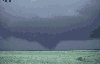
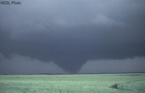
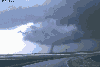 Alfalfa
OK, 22 May 1981, looking NNW. A "textbook" tornado extending from the
wall cloud of a classic supercell, with a "clear slot" cutting through
the cloud base around the near side of the wall cloud. The slot represents
part of the occlusion downdraft, an arc of sinking air believed
to contribute to tornado development in many cases. The tornado did damage
rated at F2.
Alfalfa
OK, 22 May 1981, looking NNW. A "textbook" tornado extending from the
wall cloud of a classic supercell, with a "clear slot" cutting through
the cloud base around the near side of the wall cloud. The slot represents
part of the occlusion downdraft, an arc of sinking air believed
to contribute to tornado development in many cases. The tornado did damage
rated at F2.
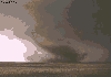
 Altus
OK, 11 May 1982, looking NW. A wide, multiple-vortex
tornado, with four or five vortices apparent to the left of the big one.
This tornado hit Altus Air Force Base and produced F3 damage.
Altus
OK, 11 May 1982, looking NW. A wide, multiple-vortex
tornado, with four or five vortices apparent to the left of the big one.
This tornado hit Altus Air Force Base and produced F3 damage.
 Binger
OK, 22 May 1981, looking SW. "Wedge"
tornado nearly a mile wide. This violent tornado produced up to F4 damage,
flattened cars before wrapping them around denuded trees, and flung cattle
and vehicles for hundreds of yards.
Binger
OK, 22 May 1981, looking SW. "Wedge"
tornado nearly a mile wide. This violent tornado produced up to F4 damage,
flattened cars before wrapping them around denuded trees, and flung cattle
and vehicles for hundreds of yards.
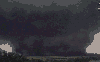
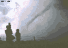
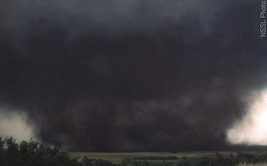
 Cordell
OK, 22 May 1981, looking N. A gust front from the parent thunderstorm
hit the bottom part of the tornado vortex and moved it aside to the right.
This tornado produced F1 damage.
Cordell
OK, 22 May 1981, looking N. A gust front from the parent thunderstorm
hit the bottom part of the tornado vortex and moved it aside to the right.
This tornado produced F1 damage.
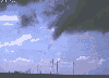
 El
Reno OK, 30 April 1978, looking NE. Rope-shaped
tornado with the main precipitation core of the supercell to the left of
the photo.
El
Reno OK, 30 April 1978, looking NE. Rope-shaped
tornado with the main precipitation core of the supercell to the left of
the photo.
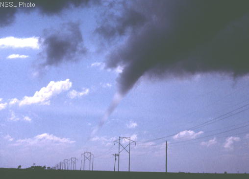
 Erick
OK, 25 April 1989, looking S. There is no condensation funnel; instead,
the inner core of the tornado above ground level is outlined by a sheath
of fine dust. The tornado hit nothing but grass and dirt -- nothing which
could indicate its true strength; therefore, it was rated F0.
Erick
OK, 25 April 1989, looking S. There is no condensation funnel; instead,
the inner core of the tornado above ground level is outlined by a sheath
of fine dust. The tornado hit nothing but grass and dirt -- nothing which
could indicate its true strength; therefore, it was rated F0.
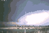
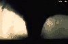
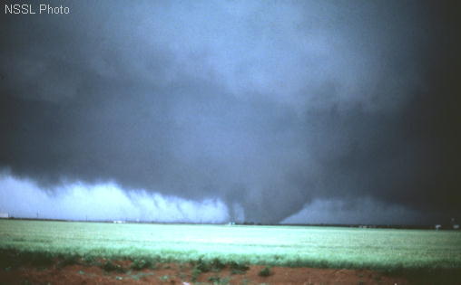
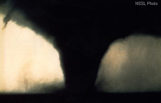
 Kingsmill
TX, 14 May 1977, looking WNW. Tornado in its dying stage. The candy-striped
effect comes from the tornado's passing across alternating areas of sun
and shadow caused by broken clouds to its upper left.
Kingsmill
TX, 14 May 1977, looking WNW. Tornado in its dying stage. The candy-striped
effect comes from the tornado's passing across alternating areas of sun
and shadow caused by broken clouds to its upper left.
 Mayfield
OK, 16 May 1977, looking N. Large tornado which produced F2 damage.
The white streak at upper left is a falling hailstone.
Mayfield
OK, 16 May 1977, looking N. Large tornado which produced F2 damage.
The white streak at upper left is a falling hailstone.
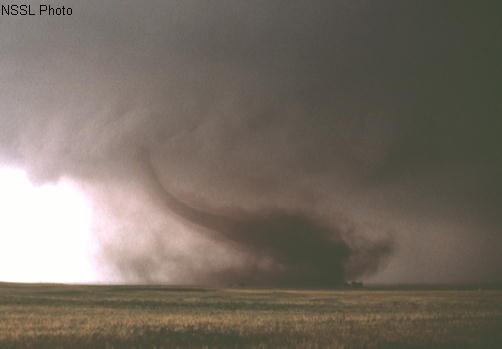
 Roff
OK, 2 May 1984, looking NW. Another "rope" tornado in its dissipating
stage. The dense gray area behind the tornado is shafts of heavy rain and
hail. It produced F2 damage.
Roff
OK, 2 May 1984, looking NW. Another "rope" tornado in its dissipating
stage. The dense gray area behind the tornado is shafts of heavy rain and
hail. It produced F2 damage.
 Seymour
TX , 10 April 1979, looking NW. Though massive and well-organized,
the tornado crossed largely open countryside, hitting flimsy outbuildings,
vegetation and utility poles. It snapped and uprooted mesquite trees, which
are deep-rooted and notoriously tough, and was rated F2 by NSSL survey
teams.
Seymour
TX , 10 April 1979, looking NW. Though massive and well-organized,
the tornado crossed largely open countryside, hitting flimsy outbuildings,
vegetation and utility poles. It snapped and uprooted mesquite trees, which
are deep-rooted and notoriously tough, and was rated F2 by NSSL survey
teams.
There are more public-domain tornado pictures from the NSSL archive
online at the
NOAA
tornado photo library. [The "high-resolution" versions may take a long
time to download on a modem.] If you want hardcopies for research projects,
the best bet is to print public-domain images from a high-quality color
printer. Even when using public-domain images, you should give proper credit
to the source.
Source: The
Online Tornado FAQ by Roger Edwards, SPC
NOTE: Having happened before the era of comprehensive damage
surveys, some of these events may have been composed of multiple tornadoes
along a damage path. Death counts for events in the 1800s and early 1900s
should be treated as estimates since recordkeeping of tornado deaths was
erratic back then.
 Alfalfa
OK, 22 May 1981, looking NNW. A "textbook" tornado extending from the
wall cloud of a classic supercell, with a "clear slot" cutting through
the cloud base around the near side of the wall cloud. The slot represents
part of the occlusion downdraft, an arc of sinking air believed
to contribute to tornado development in many cases. The tornado did damage
rated at F2.
Alfalfa
OK, 22 May 1981, looking NNW. A "textbook" tornado extending from the
wall cloud of a classic supercell, with a "clear slot" cutting through
the cloud base around the near side of the wall cloud. The slot represents
part of the occlusion downdraft, an arc of sinking air believed
to contribute to tornado development in many cases. The tornado did damage
rated at F2.
 Altus
OK, 11 May 1982, looking NW. A wide, multiple-vortex
tornado, with four or five vortices apparent to the left of the big one.
This tornado hit Altus Air Force Base and produced F3 damage.
Altus
OK, 11 May 1982, looking NW. A wide, multiple-vortex
tornado, with four or five vortices apparent to the left of the big one.
This tornado hit Altus Air Force Base and produced F3 damage.
 Cordell
OK, 22 May 1981, looking N. A gust front from the parent thunderstorm
hit the bottom part of the tornado vortex and moved it aside to the right.
This tornado produced F1 damage.
Cordell
OK, 22 May 1981, looking N. A gust front from the parent thunderstorm
hit the bottom part of the tornado vortex and moved it aside to the right.
This tornado produced F1 damage.
 El
Reno OK, 30 April 1978, looking NE. Rope-shaped
tornado with the main precipitation core of the supercell to the left of
the photo.
El
Reno OK, 30 April 1978, looking NE. Rope-shaped
tornado with the main precipitation core of the supercell to the left of
the photo.
 Erick
OK, 25 April 1989, looking S. There is no condensation funnel; instead,
the inner core of the tornado above ground level is outlined by a sheath
of fine dust. The tornado hit nothing but grass and dirt -- nothing which
could indicate its true strength; therefore, it was rated F0.
Erick
OK, 25 April 1989, looking S. There is no condensation funnel; instead,
the inner core of the tornado above ground level is outlined by a sheath
of fine dust. The tornado hit nothing but grass and dirt -- nothing which
could indicate its true strength; therefore, it was rated F0.
 Kingsmill
TX, 14 May 1977, looking WNW. Tornado in its dying stage. The candy-striped
effect comes from the tornado's passing across alternating areas of sun
and shadow caused by broken clouds to its upper left.
Kingsmill
TX, 14 May 1977, looking WNW. Tornado in its dying stage. The candy-striped
effect comes from the tornado's passing across alternating areas of sun
and shadow caused by broken clouds to its upper left.
 Mayfield
OK, 16 May 1977, looking N. Large tornado which produced F2 damage.
The white streak at upper left is a falling hailstone.
Mayfield
OK, 16 May 1977, looking N. Large tornado which produced F2 damage.
The white streak at upper left is a falling hailstone.
 Roff
OK, 2 May 1984, looking NW. Another "rope" tornado in its dissipating
stage. The dense gray area behind the tornado is shafts of heavy rain and
hail. It produced F2 damage.
Roff
OK, 2 May 1984, looking NW. Another "rope" tornado in its dissipating
stage. The dense gray area behind the tornado is shafts of heavy rain and
hail. It produced F2 damage.
 Seymour
TX , 10 April 1979, looking NW. Though massive and well-organized,
the tornado crossed largely open countryside, hitting flimsy outbuildings,
vegetation and utility poles. It snapped and uprooted mesquite trees, which
are deep-rooted and notoriously tough, and was rated F2 by NSSL survey
teams.
Seymour
TX , 10 April 1979, looking NW. Though massive and well-organized,
the tornado crossed largely open countryside, hitting flimsy outbuildings,
vegetation and utility poles. It snapped and uprooted mesquite trees, which
are deep-rooted and notoriously tough, and was rated F2 by NSSL survey
teams.